Skip to content

Blog

Presenting Mobile City Science at Cyberlearning 2017

Blog post by Deborah Silvis, RA

Reflecting on “What’s Next” for Cyberlearning

Last month I accompanied Mobile City Science PI, Katie Headrick Taylor and Co-PI Andres Henriquez to Washington, DC to present at Cyberlearning 2017 and share information about MCS and our progress on the project so far. The Center for Innovative Research in Cyberlearning (CIRCL) 2017 Meeting brought together researchers, students, and professionals in the fields of Computer Science and Learning Sciences to hear from PIs working on related NSF projects and to discuss “What’s Next” for the transdisciplinary field of Cyberlearning. Other areas of research represented at the series of meetings and keynotes dealt with VR/AR/AI, Data Science, designing learning technologies, teaching and learning Computer Science, Citizen Science, and much more. We had multiple opportunities in formal presentations, smaller working sessions, and informal discussions with colleagues from other institutions to reflect on our experiences implementing MCS so far in 2016-2017 in Chicago and New York City. This was also a chance to engage with prospective questions concerning the future of MCS in the short and long term.

Day 1 MCS Presentations

In the morning on the first day, Katie presented on MCS at a roundtable session on Collaborative Learning. Meanwhile, I sat in on Andres’ roundtable session on Empowering Youth with Technology. He began by situating The New York Hall of Science’s participation in MCS in the broader context of the Queens 20/20 project which aims to engage the youth of a small yet densely populated and culturally vibrant section of Queens (Corona) in STEM related learning. Andres described the reach of the initiative in terms of the many students and families served and how schools were involved in the partnership, highlighting Global Science Academy (GSA)*, the high school that currently serves as the site for MCS implementation in Queens.

Having provided the context for a partnership between the museum, MCS youth (and their school), and our multi-site research project, Andres provided details of facilitators’ and youths’ experiences so far. He emphasized the central idea that young people themselves were defining the matters of concern on the ground in Queens, and he explained how technology and data were framing their learning through the curriculum as well as their identification of hyperlocal community issues such as transit, public health, employment opportunities, public safety, and ecological conditions. Andres shared how, the initial Free Recall Mapping activity, youth had conceptualized their communities as both physically located near school and also in a nebulous everyday space “where I get my sandwich.”

Later that day, Katie and Andres presented together (with Lauren Birney, PI on the Billion Oyster Project) at an Expertise Exchange session on Communities of Learning: Mapping, Moving, and Discovering across Contexts. This talk was well-attended and generated excellent questions and discussion, so much so that the room literally turned into a hot-bed of intellectual activity, and we had to open the door for some fresh air! Katie spoke to what educators need to know and researchers need to consider as they support youth to develop civic literacies around “live” community-scale issues. She provided an overview of MCS, reiterating Andres’ earlier point that the fundamental starting point for MCS is a youth perspective on place, local issues, and change. She provided more details about how this has played out in Chicago and New York in the past six months. Katie posed questions for discussion related to outcomes evaluation of a design based participatory project like MCS and also about understanding the learning goals and determining a set of core experiences for youth to reach these.

Andres added the NYSCI perspective on both how facilitators were trying to balance youth-led identification of hyperlocal issues such as transit or public safety as well as support youth to contribute in an impactful way to widely held concern about public health issues such as air quality. He drew out an example of the problem of air quality (and associated high incidence of asthma among residents) in Queens and suggested that by collecting data on this problem using simple air sensor technology, youth could potentially contribute to techno-social changes such as re-routing the air traffic to and from Laguardia, the airport centered over their neighborhood. This stimulated a lively discussion in which audience members contrasted views of Smart and Connected Cities that are oriented towards professional technology designers developing novel new tools and other orientations that position citizens as experts in the kinds of innovations that might matter to them.

Themes across MCS Presentations at Cyberlearning 2017

One theme that arose in these MCS presentations was the challenge of understanding data. This exists on different levels in MCS; there are not only multiple forms of data (video, GPS, hand-drawn maps, personal time journaling) there is also a relationship between youth-collected data and researcher-collected data. While Andres shared our excitement that youth were surprisingly savvy when it came to understanding the power and utility of data, some audience members were more circumspect, suggesting that transitioning youth from collecting and analyzing to actually shaping persuasive arguments with data would be critical in demonstrating the program’s impact. This was an important point and a rich point of discussion; several colleagues provided useful ideas for how to take the kind of data youth were collecting and manipulating and help them manage and transform it into the kinds of evidence and representations that are persuasive to stakeholders.

Another theme that emerged during these discussions was related to youth using digital and geolocative technologies as part of participating in what is broadly called Smart and Connected Communities (SCC). SCC attempts to imagine, build, and make accessible innovative ideas (for example, the re-seeding of the Hudson Bay with oysters) and cutting-edge inventions (for example, robotic trashcans) that strengthen civic life at the scale of the city. An important point Katie and Andres made regarding this was how the issues and ideas that seem to get consolidated as SCC are often mis-aligned with the hyperlocal matters of concern to local residents. This difference, often between policy makers or government officials and citizens or stakeholders is particularly stark when it comes to young people. MCS, then, intervenes on this disconnect by putting youth in a position to inform decision making about what kinds of innovation would truly make a difference to communities. This resonates with a common issue in Cyberlearning more broadly: a tension between developing flashy new technologies versus using or understanding older tools (such as maps) in new ways. Of course, at the center of all of this (for MCS collaborators) is what all this means for learning.

“What’s Next” for MCS

Throughout the two days, there was an implicit- sometimes explicit- air of uncertainty about the future of Cyberlearning. What would it become in an era of changing public support for science and in light of on-going changes in technology, approaches to teaching and learning, and communities of learners (as well as communities of researchers)? While there is not such a sense of anxiety within the MCS team of collaborators, this was certainly an opportunity to consider our next steps. One issue rising to the top has to do with intentionally integrating cultural framing more fully into the project and curriculum, particularly given the highly diverse resources MCS youth, facilitators, and community stakeholders contribute to the endeavor. Another question involves what new activities MCS might incorporate next and the direction project going forward. Some options identified during the meeting, and in subsequent debriefs amongst team members, could be (a) to scale up and continue the current work with more young people, (b) to develop a set of core activities or concepts that programs would use to implement MCS on their own, or (c) to design novel tools and technologies that continue to innovate and create new activities for youth to engage in digital mapping. Cyberlearning 2017 provided a unique setting and set of human and technological resources to imagine how these different scenarios might play out and what all this would mean for communities of youth learners and the communities of scientific researchers who study them.

*Global Science Academy (GSA) and the names of its staff and students are pseudonyms.

Reflections from Remi, Part 4

This is the fourth in a series of blog posts authored by Remi Kalir, External Evaluator of the Mobile City Science project, and the first about MCS programming facilitated by the New York Hall of Science in Corona, Queens. Read Remi’s previous entries (here and here) about the Digital Youth Network facilitating MCS in Bronzeville, Chicago.

Introducing MCS in Corona, Queens

Located in New York City’s Queens borough, the neighborhood of Corona is a bustling cacophony of culture adjacent to Flushing Meadows, site of the iconic 1964 New York World’s Fair. In a city defined by generations of immigrants from every corner of the globe, Corona is currently both the largest and most densely populated immigrant community in all of New York City. In early March, MCS programming launched in Corona thanks to an established partnership between the New York Hall of Science (NYSCI) and Global Science Academy (GSA),* a public high school about two miles from NYSCI’s sprawling campus on the grounds of Flushing Meadows. The partnership between NYSCI and GSA is rooted in the work of Queens 20/20, NYSCI’s initiative to “engage children and families in creative STEM learning, develop resources for teachers and students, build out-of-school STEM opportunities, and support STEM learning for high school and college students.” Under the auspices of Queens 20/20, the ongoing collaboration between NYSCI and GSA was as an ideal testbed for the implementation of MCS in Corona.

Throughout the fall of 2016 while the Digital Youth Network (DYN) was facilitating MCS in Bronzeville, Chicago, NYSCI staff began their planning process with GSA. Andrés Henríquez, MCS Co-PI and NYSCI’s Vice President of STEM Learning in Communities, worked alongside Catherine Cramer, NYSCI’s Senior Program Developer for Science and Technology, and introduced MCS to GSA’s Principal Edwards. Unlike DYN’s implementation of MCS during the school day via a freshman science course at Evergreen Academy, NYSCI and GSA chose to position MCS as an interest-driven, afterschool program for juniors and seniors. A biology educator at GSA, Ms. Atwal, volunteered to coordinate student recruitment and oversee some aspects of the partnership. Similar to implementation in Bronzeville, whereby DYN staff facilitated MCS curricular activities, Anthony Negron, Manager of Digital Programming in NYSCI’s Education department, took the lead role for MCS facilitation at GSA.

During their planning, the New York team – Anthony, Catherine, and Andres from NYSCI, and Principal Edwards and Ms. Atwal from GSA – identified 21 after-school sessions for Tuesday and Saturday afternoons, spanning early March through mid-June. The 14 Tuesday sessions were scheduled for an hour after school, complemented by seven three-hour long sessions for Saturday afternoons. I visited Corona in late March, and observed the third session at GSA on Tuesday, March 28th, as well as the fourth session (and also the first Saturday session) on the afternoon of April 1st.


Visiting Global Science Academy

Having walked up to the fourth floor of a very large and quintessential high school located in the heart of Corona, I was a bit winded when introduced to Principal Edwards. As he welcomed me to GSA, I immediately noticed a button pinned to his blazer: “I Support Immigrant Families.” The sentiment of his button was amplified by signage posted throughout GSA (Images 1-6): “No Human Is Illegal;” “Immigrants get the job done;” “El Pueblo Unido, Jamas Sera Vencido” (the people united will never be defeated).
 

IMG_1427.JPG

Images 1-6: Posters supporting immigrant students and their families throughout GSA


GSA is a school-within-a-school, wedged into the upper hallways of a large building that occupies an entire square city block. Having started my career in a New York City public school, there was much that I recognized – uniformed safety officers, cramped hallways, noisy heaters, and the need for a fresh coat of paint. Yet a quick glance around GSA conveys little about the distinctive approach that Principal Edwards and his staff have taken toward curricular design, honoring of student culture, supportive teaching, and transformative learning. Despite appearances to the contrary, GSA is anything but a typical New York City high school.

Founded in 2013, GSA is a public school enrolling approximately 300 students and affiliated with a larger network of international-themed schools primarily (though note exclusively) located in New York City. This network of schools has developed a highly successful model for educating recent immigrant students, many of whom are emerging bilingual learners and have experienced some type of disruption to their formal education (i.e. missing perhaps multiple years of schooling while immigrating to America). To attend GSA, students must have lived in the United States for less than four years prior to their enrollment. GSA students come from 30 home countries and speak 20 different languages. The first graduating class from GSA will walk across commencement stage this June, and every graduating senior has applied to college.

Walking around GSA with Principal Edwards, I heard – more than saw – how language is utilized and celebrated as a valued learning resource for both students and staff. Like Corona, a majority of GSA students are of Hispanic heritage and many students speak Spanish. Bengali is spoken by the second largest group of GSA students. Whether in class or the hallway, students speak their native languages as a means of social support, personal expression, and as a part of academic inquiry. Students also receive regular and high-quality assistance from the school’s paraprofessionals so as to use their developing English language skills to talk, write, and interact with one another. As such, English emerges as a lingua franca among all GSA learners.


MCS Walking Audits

The two sessions I observed at GSA were both related to the MCS curricular activity of walking audits. During walking audits, small groups of learners navigate on foot (or, in some instances, on bike) among predetermined neighborhood locations indicated on a map, and while moving annotate the map with their travelled routes, missing features, inaccuracies, and other notes helpful for wayfinding. Youth might capture digital photographs that can later be incorporated as locative data into designs authored with mapping software. The goal of walking audits is for MCS participants to learn about maps, mapping conventions, and spatial data – all while moving about a familiar locale. Additionally, participants learn that different types of maps highlight, conceal (or blatantly ignore), and display different portrayals of a place, and that such representations convey varied messages about the same place. Not only are walking audits a core curricular feature introducing youth to MCS, similar “walking the neighborhood” experiences are important for adult facilitators when preparing their own place-based and mobile learning activities.


Tuesday Afternoon: Debriefing a Walking Audit

MCS programming at GSA occurs inside an old science classroom that has been converted into the school’s growing makerspace with a row of computers and a few 3D printers. Rather than desks, the classroom features tables arranged in a “U” shape (Image 7). When I entered , most of the 11 youth participants were already present, chatting casually after a full day of school as Anthony and Andres arranged video cameras for data collection (Image 8). It seemed that participation in extracurricular programming was a norm for these youth; as such, Anthony and Andres comfortably transitioned the group into the afternoon’s MCS activities.
 

IMG_1404 edited.JPG

IMG_1403 edited.JPG

Images 7-8: The MCS classroom at GSA

The first session I observed at GSA was primarily a single, whole-group discussion among the youth debriefing their first “non-tech” walking audit from the previous Tuesday. Anthony facilitated the conversation, and when I asked him later about including a technology-free walking audit followed by an extensive debrief conversation, he mentioned the importance of youth carefully “taking a look at the neighborhood.” The novelty of mobile technologies like GoPro cameras and Garmin GPS devices might distract youth from making their first nuanced observations of everyday places. When adapting MCS curricular activities to their Corona context, the NYSCI team sought to create additional opportunities to “scaffold the experience more before they [youth] jump into the project.”


Scaffolding MCS meant ample opportunity for youth to share and discuss their non-tech walking audit around Corona, and Anthony structured this debrief via questions about place and data:

  1. What did you observe?

  2. What type of data could you collect? How would you collect that data?

  3. What would be your next steps based on the data you collected? (Image 9)


In response to Anthony’s questions, students first wrote their individual responses on notecards (Images 10-12). These individual responses became rich points of reference for participants’ subsequent conversation about Corona.

IMG_1405.JPG

IMG_1416.JPG

IMG_1422.JPG

IMG_1423.JPG

Images 9-12: Debrief questions to reflect on non-tech walking audit and sample responses

While walking about Corona, MCS youth had observed local landmarks, public libraries, construction sites, and congested traffic. These observations also included people’s everyday activities – such as commuting, shopping, socializing, and playing – as were patterns like “same people, same things,” “some of the houses are alike or so similar,” and the regularity of public transportation (i.e. frequency of buses along certain routes). When asked about the type of data they might collect during a future community investigation, one GSA student noted: “Anything that catches my attention. I’ll look at it, and I’ll catch that data in my mind.” Another referenced census-like activities, indicating an interest in determining “how many buildings [are in the area] and the amount of people they can hold.” And when Anthony inquired about the types of tools students would use to collect that data, the first response was an enthusiastic “memory!” This student went on to mention notes, videos, and pictures; however, it was unclear if “memory” referred to the faculty of his mind or the affordance of a digital device (perhaps both?).

During this discussion, Anthony routinely emphasized to GSA students that “we’re researchers.” By participating in MCS, GSA students were joining a larger community of citizen scientists, including prior MCS youth from Chicago and other participants in NYSCI educational programs. The agency of youth as researchers resonated in GSA students’ responses to the question about “next steps” following community-based data collection. Youth would use their data and “present to my neighbor” or the “owners of [the] building.” Others suggested they “would use mathematical process to show my data,” and that such data could be used to “analyze changes in a project.” Throughout this debrief about place and data, I was impressed by the ways in which MCS participants repeatedly drew upon established GSA norms for rich discussion (i.e. sharing responses, active listening, building upon one another's’ ideas), as well as disciplinary terminology taught in their STEM courses: (i.e. “make predictions,” “constant rate of change”).


Saturday Afternoon: Thematic Walking Audit

I returned to GSA on April 1st, a blustering Saturday afternoon with overcast skies. Thankfully, days of near-constant rain had blown over, and so despite the cold it would be possible for Anthony, Catherine, and Andres to facilitate a thematic walking audit with GSA students. Originally scheduled for three hours, I learned the session would only last two given coordination with school security (as the first Saturday MCS session, NYSCI and GSA were still working out a few logistics kinks). Nonetheless, the session would address two primary goals. First, participants would be introduced to their MCS backpacks and the many digital and analog tools they would subsequently use throughout the curriculum. Second, they would participate in a walking audit, using various tools to capture media and notes about three locations associated with a theme. I arrived at GSA shortly before noon, and found the school quite active for a Saturday. Principal Edwards was supervising multiple extracurricular programs, and I learned from him that such voluntary activities are quite popular with GSA students. As the session began, he brought over a large container of extra lunches from other activities in case MCS participants had yet to eat.

Perhaps because this was the first Saturday session, only six of the 11 students were in attendance. As with Tuesday, Anthony easily transitioned the group into the day’s activities. Working in pairs, GSA students received a MCS backpack and began to examine various tools. As they unpacked their GoPro cameras, Garmin GPS devices, micro SD cards, and other tools to record and store data, Anthony facilitated a discussion about “best practices” for data collection with various devices. For example, because participants would be wearing a GoPro camera on their head or chest, it was important that they attend to hand movements (so as not to obscure a recording) and their body position in relation to other people and points of interest.

After familiarizing themselves with data collection tools, MSC participants began to plan their community walking audit. Anthony, Catherine, and Andres had identified four themes pertinent to both youth interests and Corona that would guide the afternoon’s walking audit: learning opportunities, physical health, transportation, and job opportunities (Image 13). The three student pairs selected one of these themes, identified three locations around Corona related to their chosen theme, and then drew a map indicating how they would travel from GSA to their locations (Images 14 and 15). Two pairs of MCS youth chose to investigate physical health around Corona, and one pair selected the theme of transportation.
 

IMG_1433.JPG

Images 13-15: Community themes for walking audit and participant maps to plan and guide investigation of themes


The team investigating transportation departed GSA accompanied by Catherine, one of the physical health teams was joined by both Andres and Principal Edwards, and I tagged alongside Anthony and the second team exploring physical health (Images 16-18). During the next hour, my team walked to a health clinic and nextdoor pharmacy, a dental office, and a pediatrician’s office. The fact that most of these offices or businesses were closed on a Saturday afternoon did not deter MCS participants from capturing digital artifacts and taking substantive notes. Moreover, our entire walking audit featured rich discussion about a variety of issues related to health and wellbeing, such as affordability ("if there are few clinics, cost is really high"), religion and culture, access to healthy and affordable food, and the proximity of health services to public transportation. A closed clinic prompted both students to speculate on the limitations of access, as "maybe people need medicine at various times." The youth also noted the importance of culture in medical care, and commented disapprovingly about a local hospital “where you need translation every 15 minutes." And as concerns the relationship of healthcare to transportation, while it could be "odd to see medical centers in residential areas," that happens a lot in Corona, and "a lot of medical centers [are] near the subway station." The thematic walking audit effectively introduced MCS youth to mobile device use and demonstrated how these tools could afford place-based data collection. Moreover, the activity helped develop youth interest in local issues as frames for continued data collection and (counter) mapping activities, particularly given the fact that two different teams selected physical health.
 

IMG_1444.JPG

Images 16-18: MCS youth participating in thematic walking audit

Brief Concluding Questions

It’s been a few weeks since I returned from New York City and my visit to GSA and NYSCI. As I reflect upon my observations, and consider my responsibilities evaluating this phase of the broader MCS project, I would like to close this blog post with some questions that I hope are useful to both MCS facilitators and researchers, as well as others interested in place-based and mobile learning:

  • How does the facilitation of mobile learning honor youth interest and also draw upon language and culture?

  • How do mobile learning curricula like MCS leverage participants’ language and cultural practices as valued resources alongside digital devices and associated media practices?

  • How are youth language and cultural uniquely beneficial resources to the development of techno-civic literacies?

  • How does the collaboration between NYSCI and GSA, which is rooted in the broader Queens 2020 effort, help support the everyday STEM practices that are central to MCS implementation?

*Global Science Academy (GSA) and the names of its staff and students are pseudonyms.

Reflections from Remi, Part 3

This is the third in a series of blog posts authored by Remi Kalir, External Evaluator of the Mobile City Science project. For previous entries, see Remi’s first and second posts to the MCS Counter Mobilities Blog.


MCS and Design Charrettes

Young people’s participation in Mobile City Science (MCS) is organized around three broad sets of mobile learning activities. Youth begin MCS by collecting data about their communities through, for example, walking audits and historic geocaches. Then they analyze their data via activities like asset mapping and, as described in my previous post, GPS drawing. And finally, they use their data to make spatial arguments. So as to support young people in arguing from data about their experiences in and analyses of everyday places, the MCS curriculum features counter-mapping activities and a final community-based design charrette.

Typically organized as the final day of MCS programming, community design charrettes serve multiple purposes. First, participating youth are provided a distinctive forum to present their mobile learning experiences and artifacts (like counter-maps) to local adult stakeholders, such as urban planners, community designers, educators, parents, and other professionals. Second, young people are supported in making data-driven arguments for changes they wish to see in their communities. For example, suggested changes may advocate for increased learning opportunities across formal and informal settings. Third, youth are able to engage with civic leaders through approximations of professional practice. For instance, interactions with urban planners can provide youth with insight into the ways in which these professionals identify pressing needs, discuss and analyze challenges, and propose solutions that inform community change.
 

From Design Charrette to Community Presentation

I recently traveled to Chicago and observed a community presentation featuring the Digital Youth Network (DYN) and a few high school students from Evergreen Academy.* Why a community presentation and not a design charrette? This decision was motivated, in part, by Evergreen’s Principal Lawrence, who invited MCS students to present at a previous civic-oriented school event and had anticipated greater turnout from invited community stakeholders. In my discussions with DYN staff, I learned of a struggle among some public high schools in Chicago to robustly engage community stakeholders around student accomplishments (whereas it is easier to quickly garner attention and broad support when more negative events afflict a school’s community). Aware of this dynamic, it is Principal Lawrence’s agenda to take advantage of opportunities whereby community members can learn more about and develop a stronger connection to Evergreen and its students. As such, it was Principal Lawrence’s idea to have her students present about MCS at an established community meeting; if Evergreen students engage adults in a community forum that typically lacks a youth perspective, then perhaps those adults and other stakeholders will visit Evergreen to support and celebrate student learning in the future.

The cumulative design charrette-turned-community presentation that I attended featured two students from Evergreen and showcased three months of MCS programming in the Chicago neighborhood of Bronzeville. The following narrative is based upon my fieldnotes, and highlights key moments from the presentation. I also include sample slides produced by youth participants (some slides have been lightly edited, when necessary, to conceal identifiable information about Evergreen and its students).


DYN’s Recent MCS Design Charrette

An early Thursday afternoon: I have arrived at Coppin AME Church in Chicago’s Bronzeville neighborhood. Coppin AME was founded nearly a century ago, in 1919. Next door to the main sanctuary is the Coppin Youth Center, built in 1962, an aged structure whose entryway features formal portraits of clergy, records of church history, and posters with information about local community services. Down a narrow hallway, past a few cramped offices, is a large meeting room with worn wooden floors. Eight rectangular tables are arranged in a large “U,” with approximately 20 chairs spread around the outer edge. At a separate set of tables, two church staff organize sandwich platters near a punch bowl and large baskets of potato chips.

I’m accompanied by Tene Gray, DYN's Director of Operations and Professional Development. We are the first meeting attendees and are welcomed warmly by the church staff who instruct us to find a seat. Tene and I – along with DYN’s Elaina Boytor and a few high school students from Evergreen Academy – are attending the second Faith-based Community Meeting of 2017. These meetings are one type of community-engagement opportunity facilitated by the Chicago Alternative Policing Strategy (or CAPS), with the faith-based meetings organized by CPD Officer Esther Halloway and facilitated by Pastor Ronald Benjamin. Eleven Faith-based Community Meetings have been scheduled for 2017, and they rotate monthly among different host churches in Chicago.

Shortly before 1 PM, Tonya and Easton, two freshman from Evergreen, arrive with Elaina. As we set up a laptop computer and projector, Elaina, Tonya, and Easton review the presentation. I learn that a third student was planning to present, but left school earlier in the day (there is some last-minute shuffling of presentation responsibilities). There are about 10 people in attendance when the meeting starts – a mix of men and women, all of whom appear to range in age from their 50s to their 80s, most dressed in formal suits. The meeting is convened by Pastor Benjamin, who notes that many in attendance are also clergy. His welcoming words are brief, and he calls up Officer Halloway for additional comments. She emphasizes the importance of youth involvement in the community.

The MCS presentation begins with an introduction by Tene Gray, who details the overarching goals of MCS, the involvement of additional teams at the University of Washington and in New York City, and emphasizes that “to really understand the Bronzeville community” the students at Evergreen “did research.” Specifically, DYN staff encouraged students to grapple with the question: “As a teenager, what would make you stay in this community, particularly after school?”

Easton presents first, sharing a summary of information about MCS in Bronzeville (Sample Slide 1), a timeline of partnership programming at Evergreen, and the core purpose and curricular components of MCS (Sample Slide 2). While he mostly reads the slides verbatim, when describing walking audits Easton relaxes into his narrative and describes the importance of this activity in greater detail; he’s quite dynamic when speaking extemporaneously and drawing from his personal experience. He riffs about his investigation of a local Popeye's restaurant (Sample Slide 3), asking: “Why is it there? Why should it be there? Should something else be there?” It's a powerful moment that captures the purpose of MCS and his passion as a participant. Throughout Easton's section of the presentation, another four meeting attendees arrive.


Sample Slide 1: Summarizing MCS activities in Bronzeville


Activities: Data, Interpretation, Sharing
Sample Slide 2: Summary of MCS activities at Evergreen Academy


Sample Slide 3: Detail about walking audit activity, with emphasis on Popeyes restaurant


During Tonya’s section of the presentation, she reads from her prepared notes and hits a stride when talking about the MCS curricular components of asset mapping and counter-mapping. Tonya emphasizes: “We brainstormed what assets were missing.” This “brainstorm” was possible because of the assets she and her peers had already mapped throughout Bronzeville (Sample Slide 4), including parks, banks, restaurants, cultural institutions, and other businesses. And among the community assets she and her peers determined to be missing from Bronzeville – and that would keep them in the area after school – a recording studio, jobs, a mall, and a place to get a job after school (Sample Slide 5). According to Tonya, “These are some things that we would like in our neighborhood.” This is evidence of Tonya, and her peers, using mobile and geospatial technologies to write their city.


Sample Slide 4: Screenshot of asset map, including placemakers, descriptions of locations, and student quotes about community assets


Counter Mapping
Sample Slide 5: Counter-mapping identified community assets missing from Bronzeville


Tonya also details specific aspects of how she and her Evergreen peers deepened their counter-mapping analysis. She emphasizes three missing assets: a) greater opportunities provided by after-school jobs, b) easier access to recreation centers (Sample Slide 6), and c) increased use of artistic studios (Sample Slide 7). Tonya underscores the importance of youth employment, noting: “We should have jobs closer to our school” because “jobs are good for resumes, especially at an early age.” As she says this, there are noticeable murmurs of agreement and head-nodding among the meeting attendees.

Recreation Centers
Sample Slide 6: Counter-map detail about recreation centers


Studio
Sample Slide 7: Counter-map detail about studios for music, dance, and art
 

Tonya and Easton come to the end of their 21-slide presentation in about 10 minutes. As they offer their thanks, all the adults in attendance offer warm and encouraging applause. Prior to the presentation, both Tonya and Easton asked Elaina and Tene about questions; it was clear they were both pretty nervous, and seemed a bit unsure about answering questions posed by adults (and, in particular, adults they didn’t already know). Perhaps as a means of preempting such a circumstance, or perhaps because he was curious, or for some other reason (and I regret not following up with him about why), Easton steps toward the attendees and improvises: “I have a quick question for all of you… How was the community before all the change… I want to know how much change you've seen in this community as a whole?” It's a dramatic moment that amplifies the room’s energy and the presentation’s resonance. Easton’s well-informed statement reflects the impact of his participation in MCS while also serving as an invitation for conversation with this important group of community stakeholders. The attendees, perhaps surprised, take a moment to respond; for a minute it seems as though no one will engage with Easton’s question.

An elderly gentleman, later referred to as a doctor, slowly stands and speaks: “I've been in this community since 1971.” We learn that he is not originally from Chicago, but has worked in Bronzeville for over 40 years and during that time has witnessed “dramatic change.” He continues: “We've lost lots of low income housing, [they’ve] tore down public housing along State street.” He pauses, before adding: “My question to you: What do you have as boundaries for Bronzeville?” Tonya and Easton aren't sure and Elaina fields his question; for the purposes of MCS, she says, the boundaries of Bronzeville were defined primary in reference to where students could easily walk from Evergreen Academy. The gentlemen responds to Elaina, “That's a very small part of Bronzeville.” This important exchange ends on a curious note about place, scale, and mobility; not only does DYN facilitate programming across Bronzeville (and, for that matter, the city of Chicago), MCS emphasizes the analysis of place from the perspective of youth and how they move about their familiar and everyday locations.

Then a second gentlemen responds to Easton’s question. There are a “huge number of residents [from Bronzeville] that have left,” he replies, “Displaced is really the word I want to use, because of public housing being torn down.” He pauses before continuing, “That's something that has affected the neighborhood in many ways. We're talking about voting, working people, the whole gamut. And people who have long-term connections to this neighborhood. The housing crisis has increased dramatically.” It’s notable that he also mentions affordable housing. Moreover, his comments echo some of the themes that youth identified and used to guide their MCS participation, including gentrification and diversity. In this respect, Evergreen students’ data collection, analysis, and argumentation efforts align well with some of Bronzeville’s enduring challenges, suggesting their MCS experience provided an accurate perspective on place, community identity, and processes of change.


Approaches to Engaging Community Stakeholders

The current iteration of MCS programming with DYN has now concluded in Chicago, and MCS implementation begins (this week!) in New York City through a partnership with the New York Hall of Science (NYSCI). As such, it is an opportune time to consider how the MCS curriculum structures engagement with community stakeholders through design charrettes and other forms of public presentation. MCS researchers and facilitators know that professionals (like transportation engineers and urban planners) and local stakeholders (such as parents, educators, elected officials) can be receptive to young people contributing to community planning processes during public and participatory design charrettes, and particularly when youth recommendations for change are supported by data. So what are some of the (emerging) approaches to this aspect of the MCS curriculum? And what may be the advantages associated with different approaches?

It appears as if there are four primary means of structuring either design charrettes or other forms of cumulative community-based presentations:

  1. One-time events organized by the implementation team, likely in partnership with professionals and other community stakeholders. This event may take place at a school, community organization, or in a municipal setting, and is organized around the type of hands-on design work that allows youth to approximate professional practice while simultaneously sharing artifacts (such as counter-maps) from their MCS experiences.

  2. A final showcase event organized by a participating school, which invites participation from professionals and other community members. The event will likely occur at school, and may combine elements of both hands-on design work and a cumulative presentation. This type of event may provide easier access for other students and educators from the school to learn about MCS activities and outcomes.

  3. Presenting MCS programming at a standing community-based meeting, such as Evergreen and DYN’s presentation at the CAPS Faith-based Community Meeting. This approach has the advantage of amplifying youth voice in settings that may (for various reasons) typically lack young people’s perspective, and brings youth into conversation with diverse audiences (such as the clergy present in Chicago).

  4. Walking charrettes: A new idea provisionally discussed by MCS researchers and facilitators are walking charrettes, whereby youth would accompany stakeholders out into neighborhood settings and highlight particular city assets and improvements. In this approach, youth might share with adults mobile augmented reality designs, and use these guiding digital artifacts to spark and sustain their argumentative practices.

The learning opportunities afforded by these different approaches to public participation are distinct and, in the case of walking charrettes, yet to be enacted. Whether by the team in New York City starting implementation, or others leading mobile learning efforts, these approaches to public engagement should be considered carefully as concerns bolstering youth voice and participation in community decision-making, supporting youth in sharing data-informed findings about their own cities, and helping young people engage with a variety of professional practices.

*Evergreen Academy and the names of its staff and students are pseudonyms.

Dear Soon-to-be Mobile City Science Implementer

I know what you’re thinking… You don’t have time to read this; you’re busy prepping to launch your own MCS program! You’re gathering drawing utensils for the Free Recall Drawings. You’re charging the Garmins. You’re doing one more neighborhood walk to find that final Walking Audit stop. Trust me, I get it. But I want to share something I did not grasp fully before I started. 

Working with students will show you how meaningful the Mobile City Science activities can be. 

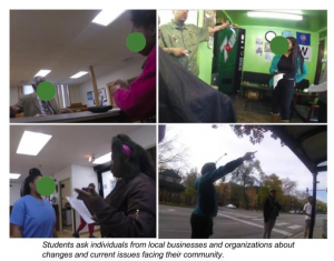
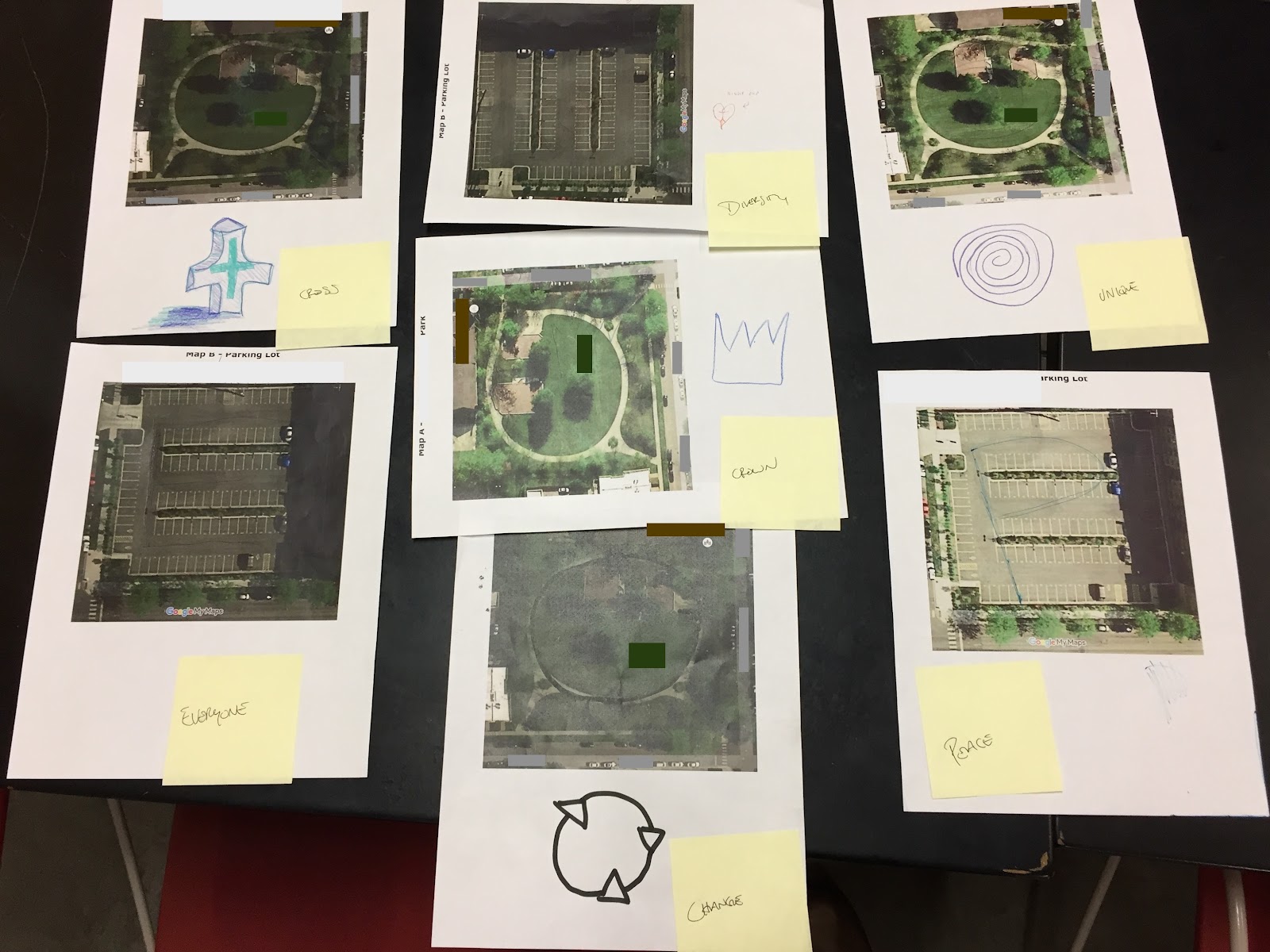
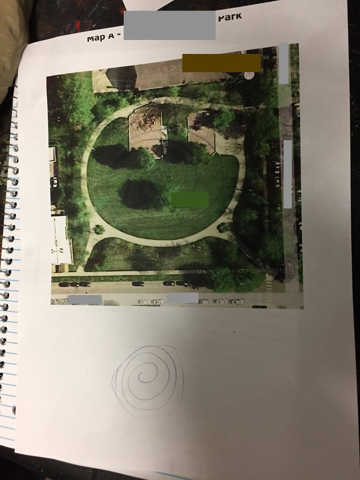
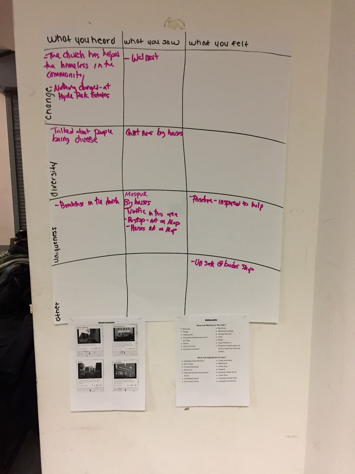
Before you start, these activities are just concepts and curriculum. You may have done them yourself with other adults. However, by seeing how students quickly take to the activities, learning what they think are assets in their neighborhoods, and hearing their arguments for area improvements, you will truly understand the impact of MCS. 

Allow me to elaborate with a few tips and anecdotes based on my experience implementing MCS with the Digital Youth Network in the Bronzeville community. I will be brief. Again, you’ve got prep to get back to.

  1. When students complete their free recall drawings, join in! They’ll get more out of it and you will, too. Being able to share our neighborhood experiences modeled for students that they could be candid about their own. And they were. Many themes came out of the discussion, including types of housing, population density, nature or lack thereof, transportation, safety, and varying positive and negative opinions about their own communities.
  2. The kids loved the Walking Audit. Leaving not only the classroom but the school; learning by being mobile and exploring instead of sitting and taking notes; using (and wearing!) high tech equipment like GoPros and Garmins—the novelty alone makes this activity a crowd pleaser. Even the staff from the school that helped us coordinate the field trips loved it, and regularly responded to their camera-wielding students. While comparing how Google Maps represented their walking path and what we saw on the walks in person, a student bluntly stated that the Google Map didn’t have things that the class cared about. Many others agreed. I was astounded by these thoughtful responses. The students were already evaluating the importance of how assets are represented in maps. They were also catching-on to the concept of defining what an asset means from their points of view.
  3. The Historic Geocache brought new opportunities for students to discover and reflect on the assets in Bronzeville. Student groups interviewed a barber shop owner, a pastor of a church, and an employee at an assisted living facility and also searched for a hidden geocache at a mosque that contained information about the establishment’s ties to Muhammad Ali. These ninth g
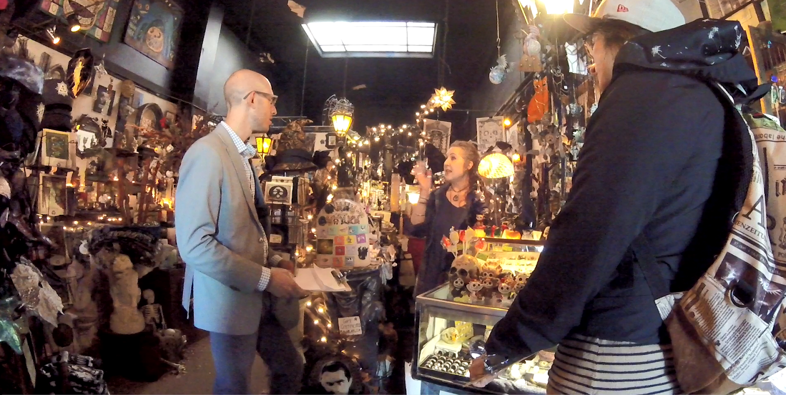
raders were new to the school (our program was held in the fall), and many were new to the area. The Historic Geocache gave them the opportunity to learn in authentic ways about the history and features in surrounding community. The group that met with the pastor learned about the church’s daily breakfasts for the homeless population in the community. After hearing about this, one student asked the pastor how she could volunteer. See what I mean by meaningful?
  4. And it gets better with their GPS Drawings. We structured the activity so that students would have a preparation day to absorb and reflect on the themes in order to come up with a symbol to represent the community. We helped facilitate conversations so that students could use the data gathered on their trips as evidence to support the community themes of change, diversity, and uniqueness. The seven teams came up with symbols that ranged from straightforward to ambitious. Each group was able to complete their drawings as well as explain what the symbol was and why they chose that for their themes. 

So while preparing the lessons, maps, and equipment, take a moment to recognize that you're working towards successfully implementing activities that will have a positive impact on your students. These experiences shaped the perspectives of our students as they mapped assets and counter-mapped the neighborhood, and will continue to shape the way in which they view their communities for years to come. These MCS activities were meaningful for us implementers, too. We learned about the Bronzeville community alongside them, but we also learned a lot about this group of students. I predict the same for you, too.

That is all. You can go back to prepping. 

Sincerely,
Elaina Boytor
MCS Facilitator 
Learning Experience Researcher at Digital Youth Network.


How to Prepare: What MCS Facilitators Need to Do/Know About the Area Before Implementing PART I

Blog post by Katie Headrick Taylor, PI & Deborah Silvis, RA


Mobile City Science has been successfully implemented in Chicago by the Digital Youth Network. As our larger group thinks about what it will take to implement in New York, we have developed an essential list of facilitator preparation for the New York Hall of Science to consider before their work with local youth. We will share this essential facilitator “guide” in two parts.


Part I describes: 1. Walking the neighborhood; 2. Talking with local stakeholders; 3. Visiting the local library; and 4. Poking around online.


Part II will describe: 5. Taking photos of the common, the impressive, and the lackluster; 6. Mapping community assets; and 7. Taking a drive with a local.


  1. Get out and walk the neighborhood

The ave.PNG

Figure 1: Two facilitators walk around the neighborhood, carrying the MCS backpack toolkit that youth will use, to get a better sense of the area.


No surprises here. MCS is all about using the moving, sensing body as the primary resource for learning about the neighborhood. Facilitators, who may be less familiar with the area than the youth with whom they will work, have to do this legwork before implementing. Walking the neighborhood helps adult facilitators answer some important questions in preparation for their MCS implementation.

  • What's the "study terrain?" 

Walking the neighborhood helps facilitators determine the boundaries of the area MCS youth can engage with on foot and also map with mobile and place-based tools. Walking the area will give facilitators a sense of any obstacles to being a pedestrian, and the main pedestrian corridors that are options for the various mapping activities (e.g., walking audit, historic neighborhood geocache). There are always many qualities about an area that are only observable on foot. Therefore, facilitators can’t rely on just their driving or biking knowledge of an area to facilitate mostly walking mapping tasks.

  • What's the neighborhood vibe?

Getting out to walk the neighborhood gives facilitators a sense of the affective qualities that saturate a neighborhood and/or community. Sometimes the way a neighborhood feels to a passerby shifts as the person moves from block to block. There may be particular areas where the energy is frenetic with people getting on and off public transit, in a hurry to get to the next place. There may be other spots that are quiet and more relaxed with many families and young children using a public parklet, for instance. Facilitators also need to know any areas that provoke an uneasy (as in physically dangerous) feeling for whatever reason, as these are locations you want to avoid sending young people into during the mobile mapping activities.

  • Are there better ways to get around? If so, why?

As a facilitator, you’ve walked around and noticed that this neighborhood isn’t very conducive to foot traffic. There are few sidewalks, and the ones that do exist aren’t connected to one another. There are several high traffic roads. Construction sites disrupt sidewalk connectivity.   What are the options for implementing a MCS curriculum here? Consider if young people could safely come to this conclusion on their own during a walking audit. If so, chances are they would have lots of suggestions for how the neighborhood could change to be pedestrian friendly. Also, consider shifting the study terrain a bit to an area that might be more conducive to walking. If walking is not an option, facilitators can consider mapping activities that use bikes or the public transit system if the urban infrastructure is more conducive to those modes of mobility.


  1. Talk with local stakeholders

Gargoyle.PNG

Figure 2. Speaking with a local business owner gave facilitators a sense of the most pressing issues facing the neighborhood.


Part of the MCS experience is for young people to get a sense of the variety of perspectives small business owners, residents, and other stakeholders have on pressing local issues. To do so, they will talk with some of these people through the mobile mapping activities, like the historic geocache. For facilitators, getting a sense of who some of these local stakeholders might be before implementing is an important step in their prep work.


In our own preparation, we have reached out to people first via email and then met with them face-to-face, and also just walked into shops and neighborhood institutions and introduced ourselves and the work (and offered our business cards with contact information). We have made sure to ask if the local stakeholder would be willing to chat with youth when/if they stopped by. These short, relationship-building conversations with local stakeholders address a few important questions when preparing for MCS implementation.

  • What are the most pressing, neighborhood specific issues?

Facilitators would be hard pressed to find an urban neighborhood or community without some “hot button” issues that are specific to the people and place. For example, in Seattle, we know that a problem at the city scale is the lack of affordable housing. However, when we dug into the neighborhood where we did our training — the University District — we quickly discovered that the most hotly contested topic for local shop owners was the issue of “upzoning” brought on by the newly built light rail station. For many longtime shopkeepers, the perception is that upzoning will dramatically change the character of the neighborhood; small businesses will no longer be able to afford their leases in new, high rise retail spaces. Knowing about this and other ongoing issues was important for how we framed the various mapping activities, and what we expected participants to encounter and have to process along the way.

  • How has this place changed recently?

All places have changed, and continue to do so. The nature of these changes can be highly specific to the neighborhood, related to the types of development happening, or planned (e.g., new road, new light rail station, new high density housing, new company opening). Sometimes it’s easier to find out details about the changes that have happened in an area at a longer historical timescale — books tell us those stories, as can long form journalism or websites (see below). But understanding the nature of recent or ongoing changes is usually best understood from talking with a local. They, of course, are living these changes, sometimes on a daily basis. How people talk about these ongoing changes can also vary greatly depending on how they perceive and experience the impact, and what their relative roles are in the neighborhood (e.g., business owner, resident, commuter, student).

  • How do locals talk about the area by name?

The name and boundaries of a neighborhood or community may seem straightforward or trivial. However, nothing could be further from the truth. In Chicago, for instance, the DYN team found that residents referred to their “home” neighborhood with a different name, and at a different grain size, than that of Google Maps or Chicago databases. Locals often specify their neighborhood or community as an area much smaller than ones that are “officially” recognized. This DYN team experience is consistent with a news story about how Chicagoans draw, name, and talk about their neighborhoods in terms that can sometimes vary radically from official maps that are used to make policy and development decisions. Implementing MCS in a neighborhood for which one has the wrong name, or inappropriately considers as having a “cohesive character” across a large geographic area, may be the death knell for facilitators.


  1. Visit the local library

Libraries – and the librarians who work there – are vital sources of local knowledge. (If you need convincing of this idea, please check out this piece by Shannon Mattern). Visiting libraries in and around the neighborhood you are learning about and chatting with people who work there can reveal hidden troves of historical and geographic information. Carefully planned visits to the library serve a number of purposes as you become familiar with background contexts and gather resources. The library itself may turn out to be a place of significance that youth find themselves exploring during MCS implementation.

  • What's the historical context of the area?

While some facilitators may already be very familiar with a given neighborhood, chances are many are not and, like the youth who will be participating, all facilitators will benefit from studying the history of the local area. Keep in mind that the history of a place is long, so consider how timescales affect what you are able to find out. When was a particular area “developed?” What have patterns of mobility meant for people who have lived in this area over tens or hundreds of years? More recently, what have been some key events that have marked the landscape or have factored into sociopolitical issues that face local residents today? When dipping your toes into the water of local history at the library, be prepared for vast amounts of information to come flowing out of library archives! Facilitators should have a plan for focusing the search, such as relevant keywords or significant dates.

  • How has the area been represented through maps? How have these maps changed?

Most libraries have map sections or map rooms, and some of these are quite extensive. Taking time to explore these resources is a way for facilitators to engage with the same representational forms youth will be examining and creating. Another reason to visit the library’s maps collection is to curate a number of exemplary maps for constructing curriculum materials. Facilitators should look for theme maps- such as maps that feature local historical markers- and choose maps that have a clear layout and are neither too “busy” nor too specific (i.e. transportation maps that depict bus lines rather than street names). Facilitators may want to consider how two maps of the same place(s) from different time periods may diverge and what this can show about changes over time. There may also be things learned during historical research at the library that remain “invisible” on some maps. Be sure to note these.


  1. Poke around online

At various stages, while facilitators are walking, riding, driving and visiting with local community members around the neighborhood, it will help to search online for more expansive information about points of interest. In addition to the digital archives at the library, internet resources will provide context and sometimes key “missing pieces” that just aren’t visible while physically out and about. As with anything else, some online resources are more suited to this than others.

  • What "digital traces" of this place exist on the internet?

The themes or topics surrounding a place that tend to accumulate online can point to what issues are salient or what historically has shaped how the place appears today. (As an example, RA Erin Riesland pointed us to this excellent HistoryLink.org resource about our Seattle study terrain.) These topics may coalesce around a key digital document. City planning documents, “master plans,” and neighborhood newsletters are all online repositories for representing processes of change in places.

  • Are there stories about this place that you've missed?

Perhaps poking around online will help contextualize for facilitators what they have seen or heard on walks and talks around the neighborhood. Alternatively, the public face of a place as seen online may differ starkly from the lived reality at ground level. Maybe the online record is not keeping pace with the changes happening at the local level. Or else the voices seen and heard online are not the same as those seen and heard in the streets on foot. Being attentive to these differences can often open up space for missing stories or perspectives or point to tensions that might play out in unpredictable ways during curriculum implementation.

Reflections from Remi, Part 2

This is the second in a series of blog posts authored by Remi Kalir, External Evaluator of the Mobile City Science project. The first post – which provides context about MCS and Remi’s role, as well as some guiding questions about project implementation – can be read here. A big thank you to DYN staff for providing helpful feedback on the writing of this post.


A Sketch of MCS

Bronzeville, Chicago: “What’s the temperature out here?” I’m standing among nine high school freshman and four adults, including Principal Lawrence and a staff member from Evergreen Academy, as well as Tené Gray and Jim Sandherr who are Digital Youth Network (DYN) educators.* We’re a block away from Evergreen at a small park. I’ve tagged along with this group from a freshman science class that is participating in the Mobile City Science (MCS) curriculum. Another six students, with two other educators from DYN, are across the street from Evergreen in a large parking lot. The student, Bryant, who asks me about the temperature is cold – hands deep in his pockets, hoodie on, he’s eager to start walking around again to warm up. I pull out my phone and confirm that yes, indeed, it’s pretty cold – a brisk 37 degrees on a cloudy morning. Perhaps none of us should be surprised; it is December in Chicago.


After a few brief instructions from Tené, the nine students break into four groups and begin a GPS drawing activity (Figure 1). Within each group, students activate handheld Garmin GPS devices, reference paper maps to walk pre-planned patterns around the park, and consult both tools and one another to record location-specific digital pathways of their drawings. As DYN implements MCS in partnership with Evergreen, this place-based curriculum has adapted to explore three themes pertinent to Bronzeville – change, diversity, and uniqueness. Student drafts of their GPS drawings are symbols that represent these themes – a cross, heart, spiral, crown (Bryant’s drawing), the letter “E” (for everyone), the letter “P” (for peace), and a circle with three arrow symbols (Figure 2).


IMG_1341.JPG

 
Figure 1: Groups of Evergreen freshman participating in GPS drawing activities at a park.


IMG_1316 EDITED.JPG

Figure 2: Student drafts of GPS drawing activity, with yellow sticky-notes added to identify the symbol and/or corresponding theme.


I follow one group, and then another around the park, taking photographs, listening to their conversations, jotting observations in my notebook. After about ten minutes, three groups have finished their GPS drawings and pair up with an adult to return to Evergreen. In the park’s center, near a large tree, two young women continue to walk, a concentrated focus guiding their steps, intent on accurately capturing their drawing via a GPS route. This is, I come to learn, their third attempt to create an elaborate spiral originating from the tree and featuring multiple concentric loops (Figure 3). Jim, a DYN educator, and I watch their technology-enhanced walking-as-drawing. When they finish, and turn back toward Evergreen, the two young women smile beneath their large jacket hoods and celebrate with an enthusiastic high five.


IMG_1314 EDITED.JPG

Figure 3: Detail of spiral pattern as “unique” symbol for GPS drawing activity.


My Visit to Bronzeville

I recently visited with DYN staff and observed their implementation of the MCS curriculum at Evergreen Academy, a high school in Chicago’s Bronzeville neighborhood. Unlike a more traditional and comprehensive secondary school, Evergreen is a high school with strong community connections. Approximately 200 students attend Evergreen, a school defined as much by a distinctive arts- and technology-infused curriculum as it is by the architecture of its facility. To describe the social and physical aesthetic at Evergreen as unique would be an understatement.


My two-day visit with DYN included multiple opportunities to observe and learn more about the MCS curriculum as implemented in Evergreen and the Bronzeville neighborhood. Specifically, I was able to: a) serve as a participant observer during two MCS sessions in first period freshman science at Evergreen; b) engage DYN educators during two debriefs that followed both sessions at Evergreen; c) conduct an interview with Evergreen’s Principal Lawrence; and d) attend a DYN staff meeting about the scope of their partnership with Evergreen, DYN’s work throughout Bronzeville, and the role that place-based curricula like MCS can play – in the words of DYN’s Caitlin Martin – in helping them “to study a hyperlocal environment” and “to partner with community organizations.”


The purpose of this post is to identify and describe three areas of adaptation that are defining the implementation of MCS in the context of a school-community organization-research partnership. This “first take” is meant to provide a useful sketch in the hopes of sparking subsequent conversation, analysis, and reflection among everyone involved in the MCS project. Additionally, this list of adaptations is one response to a question raised in my first post for this Counter Mobilities blog, “How will curricular resources be adapted to meet local needs and contingencies?” My recent participant observations, interviews, and fieldnotes suggest it is pertinent to understand how DYN is simultaneously adapting MCS across three different levels of activity, from more macro school relations, to the level of the curriculum, to more micro-level individual and group practices. First, DYN is adapting MCS to a formal school context, and one that is quite unique given the partnership with Evergreen. Second, DYN is adapting curricular structures and activities for more meaningful implementation. And third, DYN educators are adapting their professional practices of planning and facilitation.


Adapting to a Formal School Context

MCS has primarily been developed for, implemented in, and researched across less formal and out-of-school contexts. Much of what may be assumed about activity in such interest-driven learning environments – from participation incentives to the more flexible use and amount of time – are not necessarily a given in formal school contexts. At Evergreen, multiple dynamics well beyond the singular control of the school, or the school’s staff, or the students have collided in a challenging mix of unpredictability and improvisation. The following circumstances are defining this first adaptation of MCS to a formal school context:


  • Most Evergreen students do not live in Bronzeville and commute from surrounding Southside neighborhoods to attend school. The freshman participating in MCS are new to Bronzeville within just the past few months and, as such, are less familiar with this neighborhood than with the many communities within which they live. Commuting to Evergreen also impacts student attendance patterns.

  • Principal Lawrence identified a freshman science class as a promising context to implement the MCS curriculum. This class began the school year with a substitute teacher, who was subsequently replaced by a full-time educator, who has since also left and been replaced by Mr. Curtis, a long-term substitute. This turnover has made it difficult to establish effective classroom norms or a robust and routine science curriculum. Amidst this dynamic environment, DYN educators have embraced the opportunity to provide a consistent and structured academic experience during these students’ first period of their first year in high school.

  • In other contexts, MCS activities might be perceived as an attractive alternative to a more routine freshman science course (i.e. lecture- and textbook-based learning). At Evergreen, DYN educators have an impression that students perceive MCS as “school” given that, in this context, there is no regular science curriculum.

  • MCS is scheduled for three days of the week (Tuesday through Thursday mornings), with DYN educators and Principal Lawrence noting a disconnect between this programming and classroom activities on Mondays and Fridays. It has been suggested that DYN create complementary programming and/or resources that connect activities throughout the week and provide Evergreen students with more responsibility over their learning. Doing so might further establish MCS as the de facto science curriculum for this class. Mr. Curtis, for example, likes that MCS is “interactive” and build students’ technology skills.

  • The scheduling of MCS during the school day’s first period is problematic for consistent student attendance.

  • As is the case with many high schools, tardy student arrivals often interfere with first period class time. MCS introductory discussions at the beginning of class are problematic since not everyone is present, resulting in repeated instructions, and frequent regrouping of students based on when they arrive and what they have done.


Adapting Curricular Structures and Activities

The MCS curriculum is defined by a collection of mobile and place-based learning activities, including walking audits, geocaches, GPS drawing, asset mapping, counter-mapping, and youth-led design charrettes. As Tené told me, all MCS activities have been “heavily adapted to this context” (i.e. Evergreen) through the creation of multiple lesson plans by Elaina Boytor, Caitlin, and Tené through iterative cycles of unit sequencing and lesson planning, modification, critique, and revision. Many of the aforementioned activities – like geocaching and GPS drawing – have become stand-alone “units,” with up to three class session “lessons” aligned to a given unit. DYN’s lesson plans – which build upon the organization’s existing resources and staff expertise – are all pages long, and include details about equipment, set up, facilitation goals and instructions, and transitions among different stages of the lesson, as well as notes about how data will be collected and archived for researchers at the University of Washington. Although not unlike previous efforts by DYN to implement programming in local schools, MCS has required a substantial effort “breaking down” activities given both the previously noted school-level constraints and the conceptual features of some MCS activities (like creating a symbol to represent a theme that students will walk as a GPS drawing).


DYN staff have also created many original student handouts, activity scaffolds, and facilitation routines to ensure the successful implementation of MCS. For example, during my first day at Evergreen I observed a series of small group discussions designed in response to Tené and Elaina’s concern that students needed to better synthesize their prior experiences investigating throughout Bronzeville with their data and the focal themes of change, diversity, and uniqueness. Elaina had created a poster-size matrix that prompted youth in each of three groups to connect what they “heard,” “saw,” and “felt” during community-based activities with their selected themes. DYN educators were also attentive to facilitation strategies that would successfully support students in voicing connections among their experiences, data, and themes. For example, during the small group discussion that generated information for these posters, Dimress, another DYN educator, drew upon her deep knowledge of local Chicago neighborhoods and an encouraging demeanor to elicit from students substantive comments about crime rates, business development, and gentrification in historically black neighborhoods (Figure 4).


IMG_1313.JPG

Figure 4: Matrix developed by DYN staff to help youth synthesize among their experiences with place-based investigations, data, and focal themes.


The adaptation of MCS curricular structures and activities is an iterative process that continues to focus active partnering between DYN and Evergreen. In my conversation with Principal Lawrence, I learned of efforts to make MCS more culturally relevant, to establish more “immediate” connections to student interests, and to provide more frequent opportunity for students to “see the outcomes” of their participation. These suggestions extend Principal Lawrence’s involvement shaping curricular adaptation, her guidance in the creation of complementary activities for Monday and Fridays, and her hands-on assistance during class sessions (for example, she participated in GPS drawing as noted in my opening vignette). In addition, and given the expertise of DYN’s team, there are ongoing efforts to possibly pair MCS activities with blogging, video production, and other creative outputs. According to Tené, this may provide students occasion to use both MCS technology and data as a means of reflecting “on the bigger picture.”


Adapting Practices as Educators

DYN educators like Tené, Elaina, Dimress, and Jim are routinely adapting their individual and group practices to both implement MCS while meeting the needs of Evergreen students. I noticed that DYN staff carefully attended to two categories of professional practice: a) planning and b) facilitation.


In regards to planning, DYN has taken advantage of individual team members’ specialized skill sets to launch MCS. Tené is a former Chicago Public Schools educator with years of professional development and facilitation experience at DYN. Dimress and Jim have experience facilitating out-of-school learning experiences, and Elaina and Jim have served in formal research capacities during other DYN projects. And in addition to the fact that all DYN staff are rather tech savvy, Tené, Caitlin, and Jim have substantial curriculum development experience in both school-based and informal settings. This breadth of experience results, as I observed, in many impromptu and productive moments, such as when Jim and Elaina realized it would be useful to document – for their own team – the correct microphone and digital audio recorder settings in order to more efficiently prep students and leave the classroom (Figure 5). When I later asked Jim about this moment, he noted that “it [MCS technology] requires a lot of different literacies” that educators need to know well in order to subsequently support students.


IMG_1332.JPG

Figure 5: Elaina and Jim document correct equipment settings prior to GPS mapping outdoors (note their hats and layers!).


I also learned that Elaina had reorganized MCS equipment as the initial backpack-per-student plan (with each backpack containing one of every device for a set roster of students) was a mismatch with Evergreen’s inconsistent student attendance. The resulting system features backpacks that contain one type of each device (i.e. a backpack for Garmins, a backpack for audio recorders). To further aid their planning, DYN purchased large bins and set up an itemized system separating into categories various drawing, educator research, and student learning materials, and then reorganizing the system as implementation progressed (Figure 6).


IMG_1318.JPG

Figure 6: Reorganization of MCS equipment and materials for both implementation and research.


Another important planning feature has been DYN’s creation of device-specific stations. This setup is a time-saving practice that eases students into particular roles, allows for smoother check-out and check-in of equipment by device type, assigns responsibility of one device to one student for fieldwork, and distributes technical know-how amongst the facilitation team (if an educator is less proficient with a particular device they can then assist students at a different station; Figures 7 and 8).


IMG_1328 EDITED.JPG

Figure 7: Garmin station prepped for student participation in GPS drawing activity.


IMG_1329.JPG

Figure 8: GoPro station prepped for student participation in GPS drawing activity.


Finally, DYN educators are regularly adapting their facilitation practices, both in-the-moment and also upon reflection. On my second day at Evergreen I wrote the following in my notebook, “There’s a lot of improvisation despite all the detailed planning because of who has arrived by 9:15.” In this instance, Tené, Elaina, Dimress, and Jim were organizing and reorganizing on-the-fly about a dozen students into groups based upon both their participation in the previous day’s preparation for GPS drawing and also their prior experience using certain devices during MCS activities. While the class did successfully participate in GPS drawing, as noted in my opening vignette, this example speaks to broader (and perhaps unavoidable) tensions between preparation and implementation, and between intended design and enacted activity. In one of our debriefs, Tené emphasized the need for ongoing and iterative planning and professional development to address emergent problems and design working solutions, including lesson planning, the creation of complementary resources, and a review of facilitation strategies. Despite their experience, DYN educators find themselves in a situation akin to that of more novice educators engaging with new students, at a new school, while trying out a new curriculum for the very first time. This is challenging and rewarding work for DYN educators whose short-term facilitation of MCS is also the piloting of longer-term relationship-building with Evergreen and the Bronzeville neighborhood.


*Except for the organization Digital Youth Network (DYN) and their staff (who agreed to be identified), all names in this post – such as Evergreen Academy, its staff and its students – are pseudonyms.

Reflections from Remi, Part 1

remi_blog


This is the first in a series of blog posts authored by Remi Kalir, External Evaluator of the Mobile City Science project, to communicate project progress and reflect upon related questions of design, learning, mobility, and place.
 
This post is my first public contribution to the Mobile City Science (MCS) project via the Counter Mobilities blog. If you are just learning about MCS or visiting this blog for the first time, here’s some useful background information: MCS is a research partnership among University of Washington learning scientists, the Digital Youth Network (DYN), and the New York Hall of Science (NYSCI) to study how groups of youth in Bronzeville, Chicago and Corona, Queens collect data about and map their communities using mobile and location aware technologies, and how these data can subsequently support educators to better understand the places where youth live and learn. Funded by the National Science Foundation, the MCS Youth Mapping Community Learning Opportunities project aligns well with ongoing efforts by both DYN and NYSCI to strengthen connections among schools, community organizations, and civic institutions, while amplifying youth capacity to document and advocate for city-wide learning opportunities. The MCS curriculum – which features activities for youth data collection, data analysis, and spatial argumentation spanning eight to ten weeks – will be implemented twice throughout the 2016-17 academic school year; first in Bronzeville by DYN (in November, December, and January) and then in Corona by NYSCI (likely February, March, and April). The integration of MCS curricula in DYN and NYSCI programming builds upon related work by project PI Dr. Katie Headrick Taylor, such as her prior research on youth counter-mapping during a social design experiment for spatial justice. The MCS Bronzeville and Corona implementations are possible because of a week-long training at the University of Washington in Seattle, during which time DYN and NYSCI staff participated in MCS activities and developed their own familiarity with walking audits, geocaching, GPS drawing, and asset mapping.


Given this context, I’m going to share briefly about who I am and why I’m writing these blog posts. Aside from my role as External Evaluator of the MCS project, my day job is as an assistant professor of Information and Learning Technologies at the University of Colorado Denver where I research and design educator learning associated with everyday digital media practices. My familiarity with place-based and mobile learning can be traced back to the University of Wisconsin’s Games Learning Society Center, where I was a research assistant and facilitator of educators’ playful learning during my doctoral studies. For a number of years, I was involved with GLS’ now-defunct Local Games Lab, a group that experimented with augmented reality design, mobile game play, and related educator professional learning (and fun fact – various research teams involved in these projects authored two books about mobile media learning and mobile innovation and inspiration available for free from ETC Press).  


As the MCS External Evaluator I’m able to play multiple roles in relation to the various partners and the project as a whole. For example, I’ll serve as somewhat of a public historian, translating project activities and research findings to different audiences, whether the National Science Foundation or readers of this blog. I am also tasked with describing MCS curricular iterations over time, and analyzing how such changes indicate an emerging sociotechnical “genre” of learning at the intersection of mobile technologies, city science, and design practices that support youth civic literacy and community-based learning. Among my formal responsibilities, I’ll also advance a formative approach to evaluation (as evidenced by this series of blog posts), allowing me to ask questions that help to unpack implementation assumptions and articulate MCS’ guiding theory of action. Accordingly, the remainder of this posts identifies two questions that are beginning to define the early stages of the project. Each question is accompanied by some brief thoughts that may be generative for project facilitators, researchers, and readers who are interested in mapping, mobility, and learning.


How will commitments to youth interest-driven inquiry be honored and managed?

The Seattle training was expertly designed and facilitated by Dr. Taylor and her team to showcase how MCS activities like walking audits, geocaches, and asset mapping could support deep inquiry into a pressing local issue: the transformation and gentrification of the University of Washington’s “U District” amidst new “upzoning” building codes, increased public transportation options, and the loss of “mom and pop” shops to national, name-brand retailers. As much as we found our experience learning about this topic illustrative, meaningful, and – at times – infuriating, on a number of occasions DYN and NYSCI staff noted a tension between facilitator-selected and youth interest-driven areas of inquiry. How much should staff pre-plan specific topics? If such planning identifies pressing community issues, will those topics be of interest to youth participants? And how will stakeholder engagement inform (and perhaps shift) youth interest in particular issues, whether prior to, during, or even after MCS participation? For example, during the Seattle training a NYSCI staff member asked, “What are the relevant issues in Corona?” Weeks later, during a project check-in, this same staff member reported on some “community walks” conducted as part of NYSCI’s planning, and recalled a question she and colleague asked during this walk: “How far do you have to walk to get an apple?” The issue of access to healthy and affordable food appears to be a concern, but would this also be a salient topic for youth’s interest-driven inquiry during MCS? As DYN implementation has only begun, this broader tension persists unresolved; as such, it will be necessary to carefully document how both sites honor and build upon youth interest throughout all aspects of the MCS curriculum.

[As a related aside, a decade ago I helped facilitate youth participation in community-based food audits throughout New York City’s five boroughs, mapping so-called food deserts, measuring indicators of food availability and access, and helping youth use this data to advocate for the creation of the Green Carts initiative. Despite success, there are no Green Carts selling only fresh fruits and vegetables in Corona, Queens.]


How will curricular resources be adapted to meet local needs and contingencies?

MCS was developed primarily in out-of-school and less formal learning environments. Both DYN and NYSCI are partnering with schools in Bronzeville and in Corona, respectively, to implement their version of MCS. Because MCS draws upon and reflects the strengths, challenges, and distinctive features of a given locale, there are one set of challenges when adapting this curriculum from one setting to another. During the Seattle training, issues such as the density of businesses and civic services within specific neighborhoods, relevance of local issues to youth, the accessibility of transportation infrastructure, and weather were among the contingencies DYN and NYSCI staff sought to proactively manage. Moreover, the integration of MCS into the formal constraints of schooling present yet another set of challenges. In anticipation of implementation, both DYN and NYSCI staff have established trusting relationships with school leadership and classroom teachers, sequenced MCS activities within bell schedules and after-school programming, and created site-specific solutions to emergent challenges. For example, DYN staff have created “stations” (a routine approach to structured classroom activity) associated with youth’s research tasks, use of mobile technologies (i.e. GoPro and Garmin devices), and equipment management to more efficiently organize and launch community-based fieldwork. The flexibility of MCS activity structures is, without a doubt, a strength of the designed curriculum. However, it will also be necessary to carefully document curricular adaptations and local problem-solving efforts throughout both implementation cycles.

– Remi Kalir, External Evaluator

Reflection on Mobile City Science Seattle Training

Connecting lines

Catherine: We need to go in a straight line BEHIND the bus.

Tene: You mean, BEHIND this bus?

Catherine: Yes (pointing with the Garmin).

Tene: Okay, I see what you’re saying.

Catherine: And hopefully that will intersect the street? [They clarify again which direction they need to go]

Tene: Let’s try it.

Catherine: Who ever thought a triangle would be so hard?


screenshot-2016-10-24-10-18-41


Catherine and Tene were learning to implement GPS Drawing by practicing this activity in the U district of the University of Washington, where they spent four days in October participating in the Mobile City Science Curriculum training. Tasked with “drawing” a shape or word onto the map of the area using a GPS device they carried while walking around the neighborhood, Catherine and Tene had decided to try to draw the Greek letter Delta, a symbol of the changes that have taken place in (and continue to alter) the U district. In order to draw this triangular symbol, they needed to close the shape by connecting two lines they had walked with the third line, but where this line ought to be drawn was in question. In order to make this connection, they had to walk a pathway back to their starting point on the other side of Parrington lawn on UW’s campus. As they proceeded back to where their Delta had originated on 15th Avenue, with me scurrying after them with my video camera, trying to avoid tripping in the uneven grass, they walked with purpose, slowing only once to veer around a homeless man sleeping under a tree. Successfully connecting this large triangle, they went on to draw two more, one in the parking lot of the Hotel Deca north of 45th, and another in a section of Brooklyn Ave., closed off for Light Rail construction.
 

Connecting to places

I want to return to the brief moment when we bypassed the homeless man sleeping under the tree on campus, because this was more than just incidental and is emblematic of another sort of connection made during the training. One theme that arose again and again during the week- through our UW research team’s MCS training planning process, in traveling around the neighborhood during the training activities, in conversations with local business people, and throughout our training debriefs following each activity- was the social and economic tensions at play in the U district. These tensions coalesce around issues like “upzoning” buildings for business development and locating spaces for homeless youth in a neighborhood largely designed around student life. In one debrief session, Catherine commented that she almost felt more connected in some ways to the U district, where they had spent just a few days, than the neighborhood around where she works in Queens. I echo this sentiment, and I think it is not uncommon to spend years in places but not really take time to know about the rich histories- or patterns of oppression- that shape current conditions for possibility and vibrancy in cities. In some ways, the MCS training was a great opportunity for U district locals and visitors alike to feel connected to this place and some of its stories-in-the-making. We are all excited to see what emerges when we create spaces for young people to show how they are invested in change processes as well as to design for repair of dis-connection to place.
 

Connecting to people

It is worth saying that we also forged connections as research collaborators through the training week. I may have mentioned that some walking took place? Well, far from your usual academic conference or research meeting which involves mostly sitting, we actually did quite a lot of walking. Traveling by foot through the U district was a way of bringing us together over activities in-action as opposed to talking abstractly about how the activities might be enacted in other places. Several of us who are runners connected over this shared form of mobility, and runners from out of town got in a couple Seattle runs, even collecting heart rate data out on the Burke Gilman trail! We also got to connect via video chat with colleagues collaborating remotely in Chicago and NYC during the training.


Connecting technology

When we were not out on the move getting to know each other and the city, we were often inside downloading the data we had collected during MCS mapping activities. However, to get to the stage of downloading the data, literally hours of technical work had to be performed by our training team. Unpacking all the devices, setting them up to record data, learning how to operate new technologies, and making sure they were charged were on-going activities on the way to making the data available to process and debrief. “Downloading the data” is itself a black box researchers have to figure out how to illuminate or unpack in order to make visible what took place in the field. Connecting cables, adapters, cords, memory cards, and action camera harnesses all had to occur before we could actualize all the other connections waiting to be made in the U district.

–Deborah Silivis dsilvis@uw.edu